Weatherman Draw- Pryor Mountains
Weatherman Draw/Valley of the Chiefs
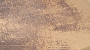
Weatherman Draw
Eighteen miles south of Bridger, MT lies an unusual hiking destination, called Weatherman Draw. At first, Weatherman Draw (also referred to as Valley of the Chiefs by many Native American tribes) seems lifeless and barren. Here there isn’t any flowing water, and only the occasional juniper tree provides shade. What does make Weatherman Draw an amazing hike has to do with the history of the Valley of the Chiefs, and the geological wonders of the area.
Rock Formation in Weatherman Draw
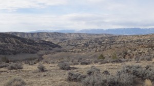
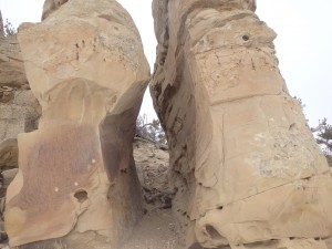
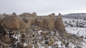
Valley of the Chiefs’ geological formations are not typical of a Montanan wilderness. There aren’t any towering granite cliffs, or evergreen forests. Instead, there are sandstone cliffs that rise hundreds of feet above the valley floor, and coulees that wind for miles through the valley. The landscape is almost surreal, with narrow ravines carved through beautiful sandstone blocks. These formations, while unusual, are formed via familiar processes of erosion.
Weatherman Draw
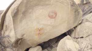
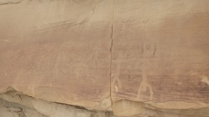
What makes the erosion processes unique in this area has to do with the amount of rainfall this area receives. Valley of the Chiefs receives so little rainfall that it qualifies as a desert- which is apparent as soon as you start hiking this dusty trail. When rain does fall, the ground acts as a barrier to the rain- the hard clay makes it difficult for rain to soak into the ground. This results in flash floods, which are responsible for many of the geological features on this trail. Although these geological features are impressive, the most interesting feature of this hike has nothing to do with erosion, but instead has to do with what features have survived erosion. These pictograph paintings that are hundreds of years old allow us to have a connection to the past, and to the heritage of some Native American tribes.
Pictograph in Valley of the Chiefs
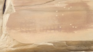
Considered sacred by Crow, Blackfeet, Comanche, Sioux, and Shoshone tribes (to name just a few), Valley of the Chiefs contains more pictograph art than any other location in North America. This valley has been used for vision quests, burials, and prayer. As such, it is imperative to step on this trail with a light foot- this valley has received enough abuse to last a thousand years. As you hike along the trails in the Valley of the Chiefs, you will unfortunately see signs of graffiti such as names scratched into sandstone boulders, and pictograph art that has been ruined by gunfire. Fortunately, this vandalism has not affected all of the art in this valley, or spoiled the geological wonders that lie down the trail.
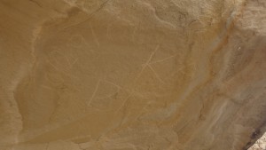
Pictograph
Finding these works of art can be something of a challenge, which makes this hike fun for everyone. Some pictograph paintings are within view from the trail, whereas others are up to a mile from the main trail. Some paintings are on the sides of boulders, a seemingly unlikely location for a pictograph; others are located on the sides of sandstone cliffs, where one would traditionally expect a pictograph to be. Since this area receives heavy abuse, writing about the exact locations of these sacred pictographs would be foolish. Instead, the only hint I can offer is to look for the telltale red or orange splotches on sandstone. If you walk up to the the splotches, you might be lucky enough to see a pictograph. If you don’t find one at first, don’t get frustrated- the nearly flat trail allows you to cover much of the valley quickly.
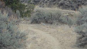
Weatherman Draw Trail
The trail itself winds up the valley, and passes smaller coulees and gorges along the way. This trail is unusual, in that it has no real destination. Instead, this hike is about getting off trail and wandering. Since the main trail passes by so many pictographs and natural features, off trail travel is a necessity. These added miles make mileage for this trail impossible to calculate. As an example, the main trail has five branches, and they all have their own side trails. Off trail travel here is relatively safe- the landscape is barren of tall trees, which makes navigation trivial. With all of these off trail options, a mileage chart could not be included on this hike.
This hike does have a couple dangers that any hiker should be aware of. From May until October, rattlesnakes are common in the area. While snakes usually avoid confrontation, the morning hours are particularly dangerous, as a snake might not have enough energy to retreat. Take care while hiking, and be sure to keep an ear out for the telltale rattle. More common than rattlesnakes (and potentially more deadly) are the rare rainstorms that move through the valley. Flash floods are common here (as you can see by the many sinkholes), and even a light drizzle can make driving difficult. Cottonwood Road becomes a muddy mess in the rain (called gumbo), which makes travel nearly impossible, even for 4 wheel drive vehicles. While these two hazards may seem risky, it fortunately rarely rains here, and the rattlesnakes are more afraid of you than you are of them.
When you are ready to leave this inspiring landscape, head back down the way that you hiked, or hike this trail on a loop. A plethora of side trips are available for this trail, which is one of the highlights of hiking in this area. At the end of the day, you won’t have an idea of exactly how far you have hiked, but you will have a better understanding of the area, and its history. The point of hiking this trail is an experience, not a destination.
Pictures of Weatherman Draw, and the Area
 Grafiti |
 Bullet holes in Pictograph |
 Pictograph |
Weatherman Draw |
Directions to the Trailhead
Heading south from Bridger, MT, turn right on Highway 72. Drive on Highway 72 for 4.7 miles, turning left onto Schwend Rd. Drive down this gravel road for 1.5 miles, turning onto Cottonwood Road. From here, it’s a bumpy 10.5 miles to the trailhead, on the left.
Map to the Weatherman Draw Trailhead
