East Fork Boulder River- Absaroka Range
East Fork Boulder River- Absaroka Range
East Fork Boulder River
South of McLeod, MT, lies the East Fork Boulder River, a popular trail that leads to less than popular destinations. The trail runs 3.5 miles to the bridge over the East Fork Boulder River, where many hikers choose to fish, camp, or hike onward to the Lake Plateau. The camping at the East Fork Boulder River is excellent, with both firewood and trout in large supply. For a novice backpacker, the low elevation gained on this hike make it a good choice. In fact, the hardest part of this hike might be driving to the trailhead itself.
After 25 miles of smooth asphalt, Main Boulder Road turns into 23 miles of potholes, and washboarded gravel. Although the road is passable in most vehicles, driving to the trailhead still takes more than 3 ½ hours from Billings, or 3 hours from Bozeman. An hour of the drive is spent on this gravel road- wake up early, if you want to make the East Fork Boulder River a day hike.
East Fork Boulder Trail 27
Parking at the spacious Box Canyon Trailhead, walk 100 yards back up the road (north), to East Fork Boulder Trail 27. The trail immediately leads past the Box Canyon Forest Service Station, heading away from the main Boulder River. With one exception, this trail does not meet the river, so your fly fishing gear shouldn’t see too much action on the hike there.
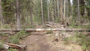
An Obstacle Along Trail 27
The East Fork Boulder trail immediately leads into a forest, following an old wagon trail. The trail is surrounded by lodgepole trees, which sometimes fall on the trail, but require only modest acrobatic skills to maneuver around. Hopping over the occasional log, the East Fork Boulder River first appears, after approximately 2 miles.
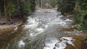
East Fork Boulder River
Some day hikers will stop at this point, and spend most of their time here. The rapids create many pools for trout, and the shade is ever present. If nothing else, this spot is a great excuse to drop your pack, and take a break. For another 1 ½ miles, the trail will lead through thick forest- this is the only time that the trail meets the river.
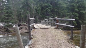
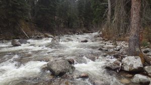
East Fork Boulder River Bridge
This dense forest is occasionally broken by a rock field, meadow, or campsite, making the last 1 ½ miles go by quickly. This trail is a popular overnight spot for hikers destined to the Lake Plateau, and the many campsites by the trail are a testament for this. After passing by these campsites, the East Fork Boulder River gradually grows louder. At 3 ½ miles, the trail crosses the East Fork Boulder River, ending the hike for many day hikers and fishermen. For others, hiking further down the trail leads to Lake Kathleen, Lake Columbine, and the Lake Plateau.
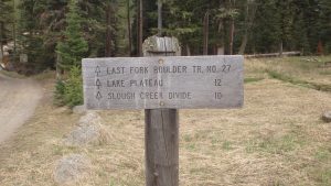
Directions to the Trailhead
Follow highway 298 south from Big Timber for approximately 25 miles, where the road turns to gravel. At that point, continue following the gravel road for another 23 miles, arriving at the Box Canyon Trailhead. The East Fork Boulder Trailhead is at the north end of the large parking lot.
Map to the Box Canyon Trailhead