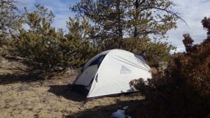
Cottonwood Road BLM- Pryor Mountains
Cottonwood Road BLM
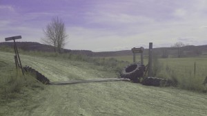
Cottonwood Road BLM
Most people think of a beautiful lake or a scenic alpine view, when they think of hiking. They imagine a beautiful drive to the trailhead, where they might see a cascade of water rushing down the valley, or evergreen forests that surround the road. Most people overlook the Cottonwood Road area, which is equally beautiful in its own right. Covered only with sagebrush and a few juniper trees, Cottonwood Road’s beauty is something you have to hike away from the road to appreciate.
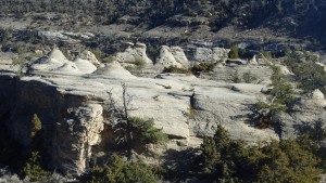
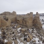
Castle Rock Formations
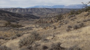
Hidden behind the hills and valleys are geological wonders: boulders, cliffs, and sandstone columns that have been sculpted by wind and water into beautiful works of art. Layers of red clay the sandstone create patches of color on an otherwise brown canvas. Impossibly well balanced sandstone blocks rise hundreds of feet above the valley floor, creating these interesting castle rock formations. Cottonwood Creek stretches its fingers through the valley, creating deep ravines in the soft sedimentary rock and clay soil. Hiking here might get your boots dirty, but it sure is worth it.
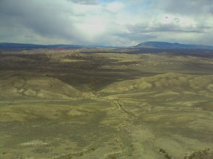
Access to Cottonwood Road can either require a 4 wheel drive vehicle during the winter and spring, or allow a passenger car in the summer and fall. Spring is certainly the most beautiful time of year to visit the area, with winter being a close second. The clay road immediately turns to mud at the slightest hint of moisture, which makes this road ideal in months with the least amount of moisture. Fortunately, the road quickly dries out after a few days of sunshine. If the road is dry, this area’s many geological wonders and recreational opportunities can be easily accessed by driving down Cottonwood Road.
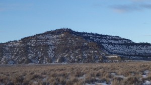
Deer Mountain
Deer Mountain is the first feature that you will see as you drive down Cottonwood Road, appearing on the right side of the road as soon as you cross the BLM boundary. Deer Mountain is the only mountain in this area, rising a minuscule 500 feet above the floor. Despite its humble elevation, Deer Mountain is worth the hike, and offers excellent views of the valley below. From here you can see the hundreds of game trails that cross this valley, which would be a nightmare to navigate in a forest; thankfully the short grasses and shrubs make navigation trivial.
Cottonwood Road from Deer Mountain
To hike to Deer Mountain, start by heading less than a mile southwest. You can use the established ATV road for this portion of the trail, which allows easy footing in the beginning. Once you have reached the heavily eroded cliffs, the easiest path is to switchback up the ridge connecting to Deer Mountain, and then hike/crawl up to the top of the mountain. No climbing skills are required to reach Deer Mountain, and while it’s a short hike to the top, it makes for an incredible view of the valley below.
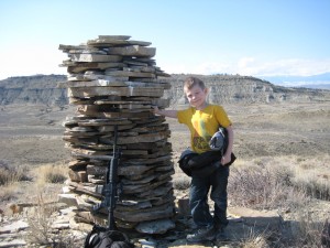
Sheep Herder Monument
Moving further down Cottonwood Road, the turn for Hatcher Pass appears. This road leads off to the right, and then down into another coulee. The road here is rough, and mundane compared to the more accessible areas along Cottonwood Road. An interesting side trip, however, is to hike to the top of the ridge before Hatcher Pass, and to the sheepherder monument there. Hundreds of rocks are stacked on this tall cairn, and the view of Cottonwood Road is impressive. As awesome as these scenes are, they pale in comparison to what lies ahead.
Driving 7 miles down Cottonwood Road rewards you with the turn off for Castle Coulee, a unique rock formation. Walking from the makeshift parking area at the intersection with Cottonwood Road, the road immediately heads downhill. Although this road used to be navigable with a four wheel drive vehicle, recent sinkholes have made this road dangerous. It’s better to hike to the coulee from this parking area, which is only a few hundred yards away.
Castle Coulee
Walking down this road, you can see the steep sandstone cliffs give way to a castle rock formation, parallel to a steep cliff. Hiking up either end rewards you with beautiful views of the valley underneath, where you can see for miles. The castle rocks make for an interesting scramble, their unusual shape provide a challenge for any hiker to maneuver around. Looking in between the fingers of the formation, you can occasionally see windows in the sandstone blocks. As time passes, these windows grow larger through the processes of erosion, cutting the sandstone block into two different sections. For now, you can hunt for fossils in this area, watch for the many raptors in the air, or continue down Cottonwood Road for a site more interesting yet.
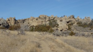
Weatherman Draw
Eighteen miles down Cottonwood Road, the trail to Weatherman Draw is the most popular feature of the Cottonwood Road BLM. Sandstone cliffs rise above the dusty floor, very similar to Castlerock Coulee. Unlike Castlerock Coulee, Weatherman Draw contains a countless collection of pictographs. Decorating the steep sandstone cliffs, these paintings provide a last connection to civilizations up to 900 years old. Weatherman Draw was called Valley of the Chiefs by some Native American tribes, another example of the U.S. government renaming a place that has been named by Native Americans for hundreds of years. Comanche, Blackfeet, Crow, Sioux, and Cheyenne tribes all consider this valley to be sacred, which requires a different level of respect than most trails. It therefore goes without saying that you should hike lightly on this trail.
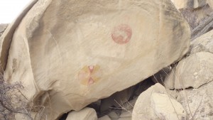
Pictograph at Weatherman Draw
Hiking into this valley, you immediately appreciate the area’s religious significance. This is a unique area, government agencies and private organizations have worked together to preserve this valley. A sign on the trail warns against vandalizing the surrounding rock features, and threatens jail for offenders. Vandals in the past have vandalized pictographs on this trail, ruining the chance for future generations to view them. Do a good deed on this abused trail, and pick up trash wherever you see it. This trail is sacred to many, and it should be treated as such. Show respect for these cultures while hiking in the Valley of the Chiefs.
Campsite at Bobcat Pass
Continuing down Cottonwood Road, you will see the turn for Bobcat Pass on the right. This rough road takes you in the opposite direction of Weatherman Draw, heading along sandstone cliffs. This road should not be driven by the faint of heart, and a sign at the turn for Bobcat Pass warns drivers of this. No hiking trails exist on this road, but there are plenty of discoveries to be made in the surrounding cliffs. The hunting opportunities are good however, with pheasants, grouse, rabbits, and coyotes all common in this area.
Driving down Cottonwood Road further leads to highway 310. You’ve driven past miles of public land, acres of wind carved landscape, and historic pictographs. You’ve also driven past discarded soda cans, used targets, and other rubbish. Make every effort to remove garbage from this unique area, as every effort helps. This area desperately needs visitors who are willing to help preserve the Cottonwood Road BLM.
Pictures of Cottonwood Road, and the Area
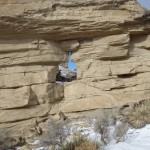 Window in Sandstone |
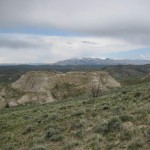 Pryor Mountains in Distance |
 Pictograph |
 Weatherman Draw |
Directions to the Trailhead
Heading south from Bridger, MT, turn right on Highway 72. Drive on Highway 72 for 4.7 miles, turning left onto Schwend Rd. Drive down this gravel road for 1.5 miles, turning onto Cottonwood Road.
Map to Cottonwood Road
